Before you go
- Vehicle
- High-clearance recommended
- Permit
- Not required
- Peak altitude
- 1300 m
- Cell coverage
- None
- Fuel
- Fill up fully in Almaty before departure. Taldykorgan (270 km from Almaty on the A-3) has reliable stations — use this as the final fuel stop. No fuel is available in Tekeli or along the Koksu valley track.
- Road status
- Almaty to Taldykorgan: 270 km on the A-3 highway, paved. Taldykorgan to Tekeli: 40 km on R-122, mostly paved. Tekeli to Eshkiolmes ridge approach: 20–30 km unpaved track along the Koksu riverbank, with stream crossings. High-clearance vehicle required for the off-road section. Track impassable after heavy rain or when Koksu is in spring flood (April–May).
- Closed months
- Jan, Feb, Mar, Nov, Dec
About this trip
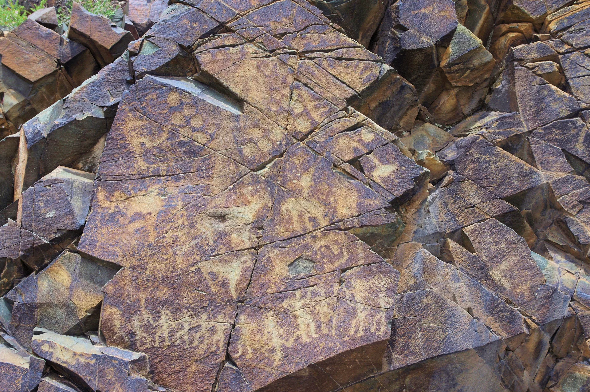
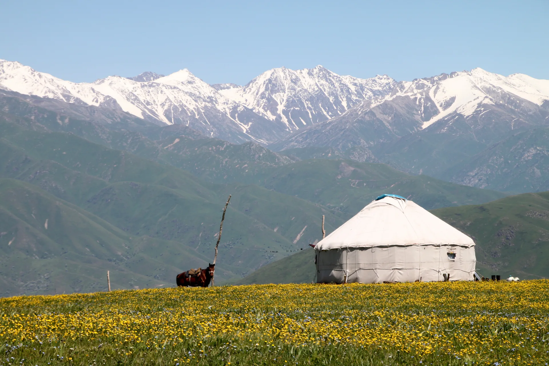
The Eshkiolmes ridge is a 30-km western spur of the Dzungarian Alatau, rising steeply from the north bank of the Koksu River to between 850 and 1,300 m above sea level. Archaeologists A.N. Maryashev and K.M. Baipakov documented the site from 1982 onwards; the 2005 monograph by Baipakov, Maryashev, Potapov, and Goryachev remains the primary catalogue. The ridge is divided into 24 numbered gorges; over 10,000 individual engravings have been recorded, with new panels discovered during each survey season. The site was nominated to the UNESCO World Heritage Tentative List in 1998 as part of a mixed cultural and natural nomination alongside Kulzhabasy and Bayan-Zhurek.
Three distinct artistic layers are legible on a full-day ridge walk. The Bronze-Age Andronovo horizon (roughly 12th–9th century BCE) produced ibex with scroll-curved horns, bull compositions with twisted ring-shaped horns, chariot scenes, and hunting tableaux. The Saka Iron-Age layer (6th–4th century BCE) is concentrated in gorges 10, 12, 13, and 20: deer in the full curvilinear 'animal style' with branching antlers thrown back over the hindquarters, panthers, wolves following rams with jaws open, and warrior imagery in armour. The early Turkic medieval layer (6th–8th century CE) is the rarest find: Orkhon-script runic graffiti cut directly alongside zoomorphic images, illustrating the cognitive shift from purely visual representation to mixed visual-textual communication. This script is the same writing system documented on the Orkhon memorial steles in Mongolia; Eshkiolmes remains one of its few petroglyph-context occurrences in Kazakhstan.
The site has no entry fee, no ticket office, no on-site guide requirement, and no fencing. Access requires a high-clearance vehicle for the 20–30 km of unpaved track from the village of Eshkiolmes toward the ridge approach; the track skirts the Koksu riverbank and passes through stream crossings that can be impassable after heavy rain. The nearest overnight base is Tekeli (40 km from Taldykorgan), a former Soviet lead-zinc mining town with basic guesthouse accommodation. Supplies and fuel are available in Taldykorgan, the regional capital of Zhetisu, 270 km from Almaty on the A-3 highway.
Visitor etiquette at the site is a factual constraint, not a request: do not touch the engraved surfaces. Skin oils degrade the patina on which the carvings depend for visual contrast; chalk-rubbing and tracing destroy surface detail. Petroglyphs that have survived 3,000 years of Kazakh steppe climate are damaged in minutes by contact. Photograph with raking sidelight in the morning; afternoon light on south-facing panels is also effective.
Route
Skip map, jump to step listWhere to sleep
- Night 1 of 1Nyala ResidencesGuesthousePremium
Budget · ~8–15k KZT/night. Mid-range · ~15–40k KZT. Premium · ~40k+ KZT.
Itinerary
Stop 1
Almaty
Depart Almaty on the A-3 highway heading northeast toward Taldykorgan. The A-3 leaves the city via the ring road and crosses the Kapchagai reservoir dam roughly 70 km from the city centre. Plan to leave by 06:30: the drive to Tekeli is approximately 5 hours including the Taldykorgan fuel stop, and an early arrival at the ridge gives the best morning raking light on the south-facing petroglyph panels. The route is straightforward on a fast paved highway until Taldykorgan. Fill the tank in Almaty before leaving; do not rely on finding fuel between the city and Taldykorgan at early morning hours.
Tip: Leave before 07:00. Carry cash — ATMs beyond Taldykorgan are absent. Download offline maps for the Tekeli–Koksu valley section before you go; mobile coverage drops to zero past Tekeli.
Stop 2
Kapchagai Reservoir crossing
- From previous:
- 70 km · 60 min drive
The A-3 crosses the Kapchagai Reservoir via the dam road approximately 70 km northeast of Almaty. The Kapshagay Hydroelectric Power Plant has impounded the Ili River here since 1970, forming a reservoir roughly 100 km long. The crossing takes 10 minutes; the wide flat water and semi-desert shore on both banks mark the transition from the Almaty basin steppe into the open Zhetisu region. Continue northeast on the A-3 after the crossing — do not turn off toward the Kapchagai resort town. The road ahead runs through open steppe with the low ridges of the Malaisary range to the south and flat semi-desert plains to the north.
Stop 3
Taldykorgan — fuel and supplies
- From previous:
- 200 km · 150 min drive
- Stay:
- ~1 h
Taldykorgan is the regional capital of Zhetisu Oblast and the last reliable supply point before the Koksu valley. The city sits on the Karatal River at the western foot of the Dzungarian Alatau, approximately 270 km from Almaty and 3.5 hours by car on the A-3. Fill the tank completely here — there are no fuel stations in Tekeli or along the Koksu track. Stock up on food and water for two days; the site has no vendors and the track to the ridge is 20–30 km of unpaved driving beyond Tekeli. Supermarkets and a bazaar are on the main Taldykorgan–Tekeli road. ATM machines are available in the city centre. From Taldykorgan, the R-122 road runs 40 km southeast to Tekeli.
Tip: Fill tank to full here — this is the last reliable fuel. Withdraw cash; no ATMs in Tekeli or beyond. The R-122 to Tekeli is signed from the eastern edge of Taldykorgan.
Stop 4
Tekeli — overnight base
- From previous:
- 40 km · 40 min drive
- Stay:
- ~12 h
Tekeli (population roughly 30,000) is a former Soviet lead-zinc mining town 40 km from Taldykorgan via the R-122. The town sits at 1,000–1,100 m elevation in a narrow valley between Dzungarian Alatau spurs, founded in 1939 when construction of the Tekeli Lead-Zinc Factory began. The factory complex, now partially operational, forms the town's eastern skyline. Accommodation is limited to basic guesthouses; options include a small hotel associated with a petrol complex on the northern edge of town, approximately 15 minutes' walk from the centre. Book ahead during summer months when trekking groups pass through. The town has a bazaar open until 18:00, a pharmacy, and a small supermarket. Mobile coverage (Beeline/Kcell) is intermittent in the valley and absent beyond town. Tekeli is the last habitation before the Eshkiolmes track.
Tip: Book the guesthouse by phone before arriving — Tekeli has very limited rooms. Confirm road conditions to the Eshkiolmes track with locals or the guesthouse owner; the track can close after rain. Dinner options are limited to the bazaar food stalls.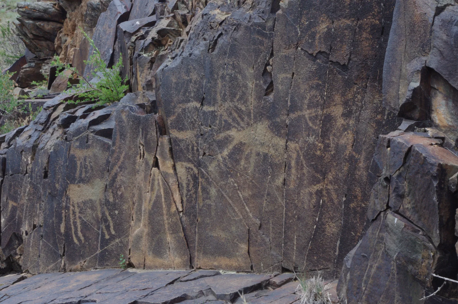
Stop 5
Off-road track to Eshkiolmes ridge approach
- From previous:
- 25 km · 75 min drive
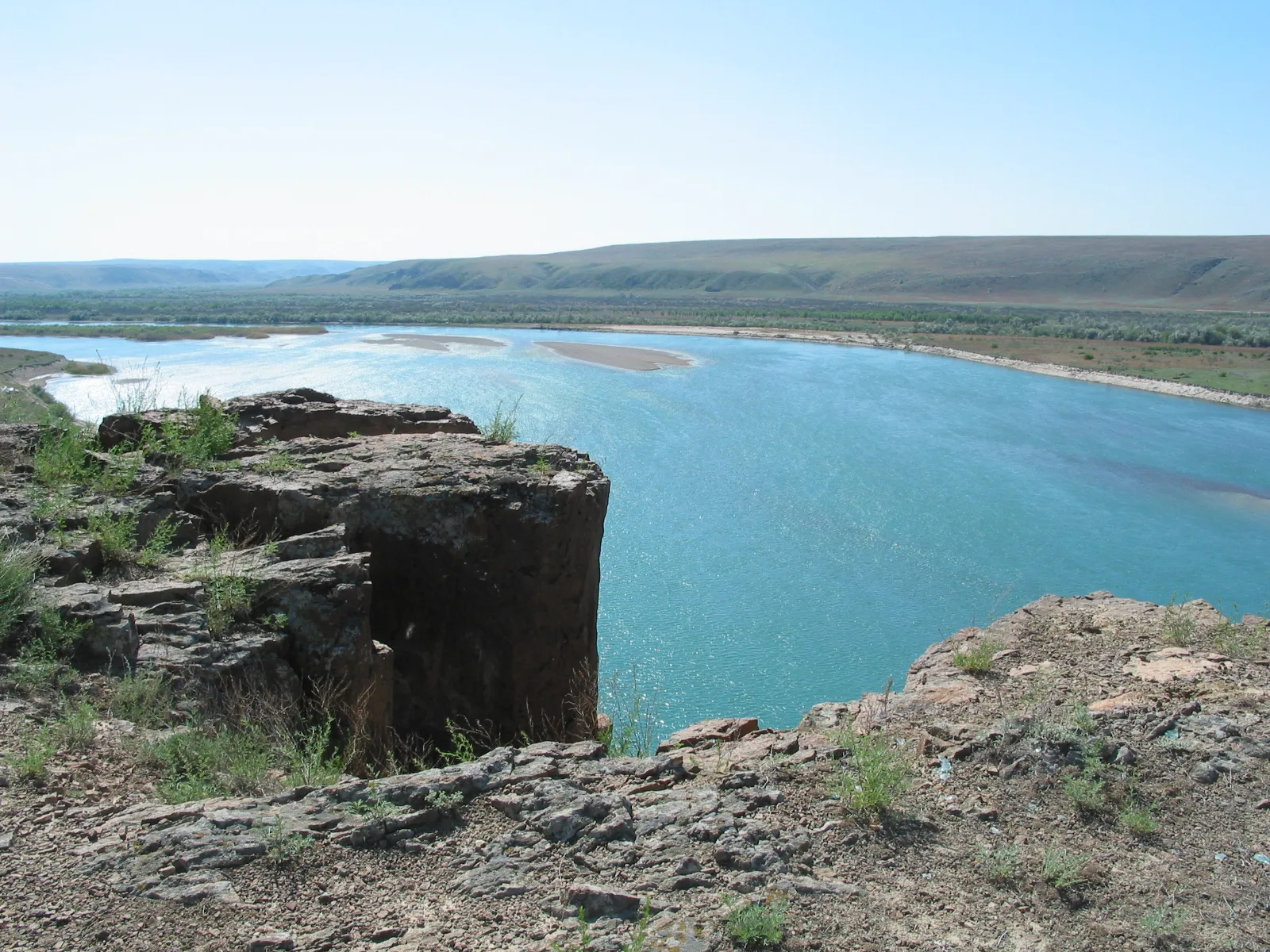
From Tekeli, head south on the unpaved track that follows the right (north) bank of the Koksu River. The track is 20–30 km to the main petroglyph access point and involves several stream crossings and rocky sections through dry river terraces. The Koksu runs milky-blue from glacial sources in the Dzungarian Alatau; the valley floor is narrow with steep gorge walls closing in as you approach the ridge. The track skirts the southern foot of the Eshkiolmes ridge and is passable to high-clearance vehicles in dry conditions. In wet weather or during spring snowmelt (April–May), the Koksu crossings become dangerous and the track turns to deep mud. Allow 1–1.5 hours for the approach drive from Tekeli. Park at a wide section at the ridge base — there is no formal parking area.
Tip: Check the Koksu crossing condition before committing — turn back at Tekeli if the river is visibly flooded. A high-clearance vehicle is necessary; standard SUVs with low ground clearance will bottom out on rocky sections. Traction boards are useful insurance.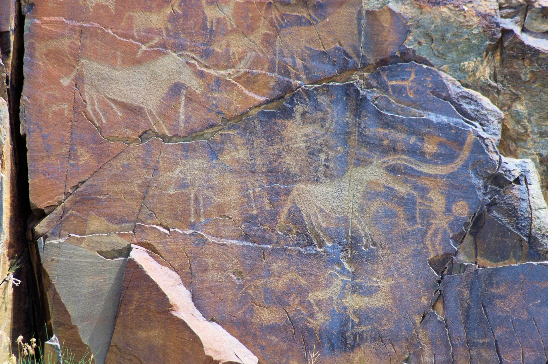
Stop 6
Lower-ridge Bronze-Age sector
- From previous:
- 5 km · 10 min drive
- Stay:
- ~4 h
The lower gorges of the Eshkiolmes ridge (particularly gorges 1–9) concentrate the oldest petroglyphs, attributed to the Bronze-Age Andronovo horizon (12th–9th century BCE). Panels are carved on dark-patinated igneous rock faces in the gorge walls at 850–1,000 m elevation. Characteristic Bronze-Age imagery at Eshkiolmes includes ibex with large scroll-curved horns, bulls with ring-twisted horns, chariot compositions with paired draft animals, and multi-figure hunting scenes. The engravings are produced by deep pecking with a stone point, creating a pale scar against dark rock patina — most visible with low-angle raking light in the morning or late afternoon. A single gorge can take 2–3 hours to walk and photograph thoroughly. Maryashev documented that panel density increases in the upper reaches of each gorge where the rock is most sheltered. Do not touch the carved surfaces.
Tip: Morning is the best light for south-facing panels. Carry a telephoto lens or a zoom in the 80–200 mm range — many panels are on vertical faces above head height. Do not use chalk or wetting to enhance contrast; both destroy the patina.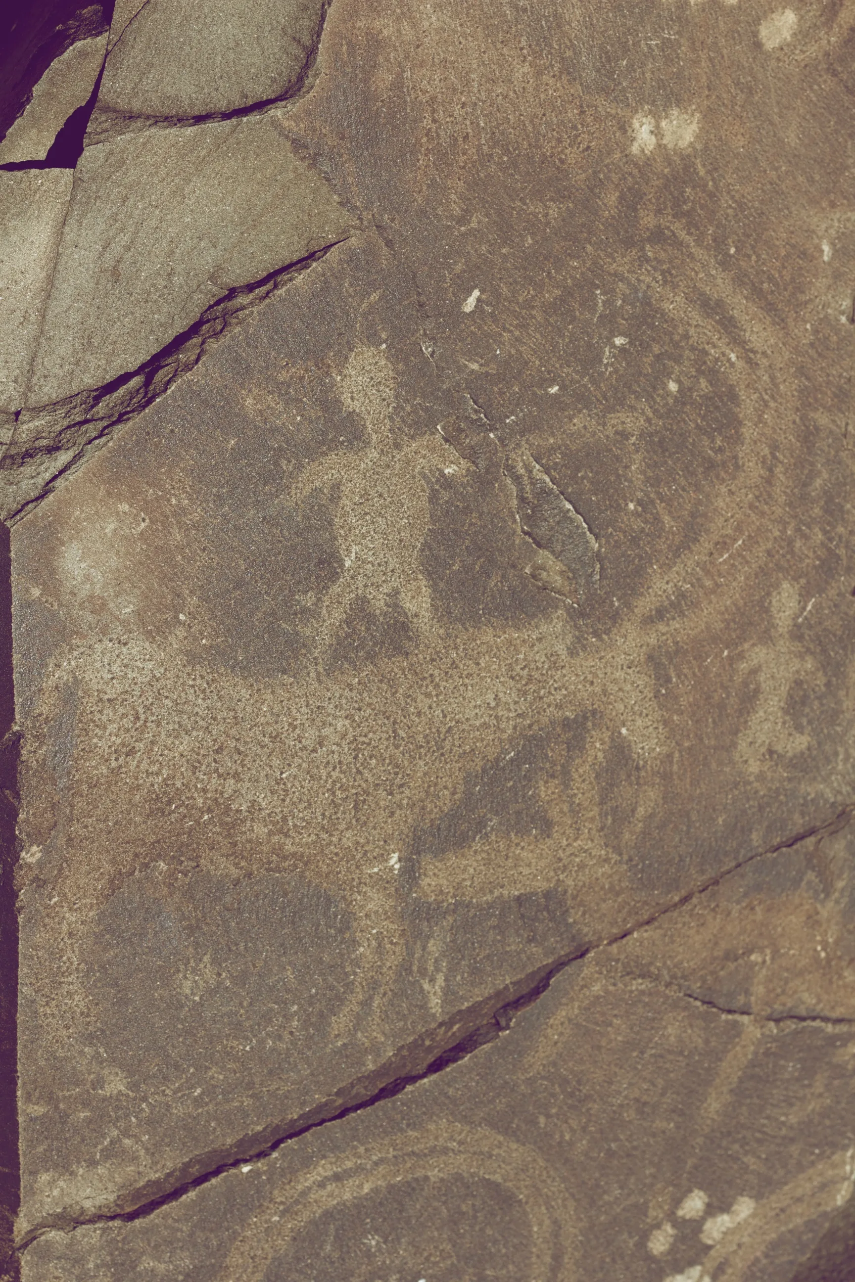
Stop 7
Upper-ridge Saka and Turkic sector
- From previous:
- 3 km · 15 min drive
- Stay:
- ~4 h
Gorges 10, 12, 13, and 20 of the Eshkiolmes ridge hold the densest concentration of Saka Iron-Age imagery (6th–4th century BCE), documented by Maryashev and Nuskabayev as representing the peak artistic period at the site. Saka animal-style motifs at Eshkiolmes include deer with full branching antlers thrown back over the body (a hallmark of the 'deer stone' compositional tradition), wolves following rams with exaggerated open jaws, panthers, and boars with hypertrophied tusks. The individual figures show multiple variants in a single gorge — Maryashev identified at least four-to-five distinct deer conventions side by side. Intermixed with these are the early Turkic medieval engravings (6th–8th century CE), identifiable by Orkhon-script runic characters — the same script used on the Bilge Khagan and Kul Tigin memorial steles in Mongolia's Orkhon Valley. At Eshkiolmes, short runic sequences appear alongside zoomorphic imagery rather than as formal monumental inscriptions, suggesting graffiti by literate Turkic pastoralists reusing a sacred landscape.
Tip: The runic graffiti is easiest to distinguish from zoomorphic imagery by its linear, angular character strokes. Carry a printed reference to Old Turkic (Orkhon) script if you want to identify individual characters. The panels are not signposted — the 2005 Baipakov et al. monograph has gorge-by-gorge plans and is the most reliable field guide.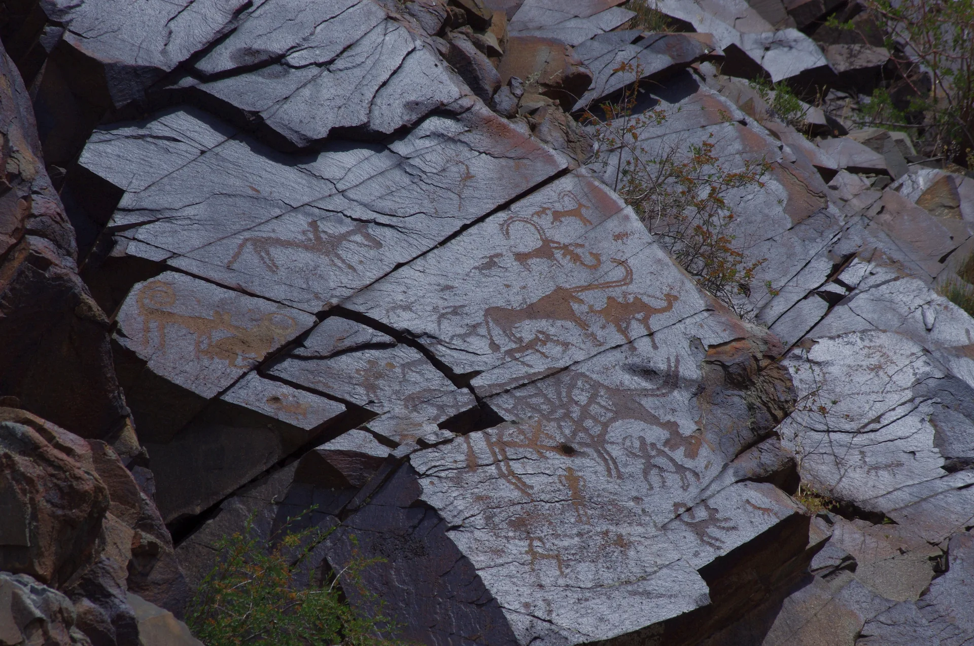
Stop 8
Return via Tekeli and Taldykorgan to Almaty
- From previous:
- 302 km · 280 min drive
Retrace the Koksu valley track to Tekeli and then the R-122 to Taldykorgan. The return drive from Tekeli to Almaty is approximately 310 km and takes 4–5 hours on the A-3 highway. Plan to leave the ridge by 14:00 on day two to clear the off-road section in daylight and reach Almaty before 20:00. If time permits, a brief stop at the Kapchagai reservoir viewpoint on the return offers a contrast to the mountain terrain. The A-3 between Taldykorgan and Almaty passes through Kapchagai and the Ili river valley; fuel is available again at Taldykorgan if needed. The route is well-signed throughout. Almaty ring road traffic is moderate in the evening; expect 30–45 minutes for the final city crossing.
Tip: Leave the ridge by 14:00 to clear the Koksu track in daylight. The unpaved section is harder to navigate at dusk. Refuel in Taldykorgan if the tank is below half — the A-3 has limited stations in the 200 km between Taldykorgan and Almaty.
Night 1 of 1 · after Step 4: Tekeli — overnight base
Nyala ResidencesРезиденции Ньяла
A small Tekeli guesthouse option before the Eshkiolmes ridge track. It keeps the overnight in the last real town on the route and is a more direct fit than dropping all the way back to Taldykorgan when Tekeli supply is available.
- Breakfast
- Cafe
- Wifi
Small property with limited room count.
Also nearby
Welcome Hotel TaldykorganHotelMid-range· City-center access
Welcome Hotel Taldykorgan
A current Taldykorgan city hotel option for the Ushtobe route. It keeps both nights in the last full-service city before and after the memorial visits, which makes dinner, pharmacy, and resupply simpler than sleeping in Ushtobe itself.
- City-center access
- Private rooms
City hotel; use as the primary repeat overnight for the Ushtobe itinerary.
Also featured on: Ushtobe — Koryo-saram Memorial
What to bring
- Water (4 L per person per day — no water sources on the ridge)
- Food for 2 days (no vendors at the site)
- High-clearance 4WD vehicle
- Offline maps downloaded before Tekeli (OsmAnd or Maps.me)
- Traction boards or recovery equipment
- Sun hat and sunscreen (ridge fully exposed)
- Sturdy boots for rocky slope walking
- Camera with telephoto lens (80–200 mm ideal for petroglyph detail at raking light)
- First-aid kit
- Cash in KZT (ATMs available in Taldykorgan only)
- Warm layer (ridge wind cools rapidly after sunset at 1,300 m)
Sources
Researched from English and Russian sources. Inaccuracies are mine.
- https://en.wikipedia.org/wiki/Eshkiolmes_Petroglyphs
- https://ru.wikipedia.org/wiki/%D0%95%D1%88%D0%BA%D0%B8%D0%BE%D0%BB%D1%8C%D0%BC%D0%B5%D1%81
- https://welcome.kz/en/info-cities/zhetysu-oblast/eshkiolmes
- https://silkadv.com/en/content/tour-petroglyphs-bayan-zhurek-and-eshkiolmes
- https://silkadv.com/en/content/cave-paintings-eshkiolmes-subjects-art
- https://informburo.kz/stati/vozmozno-postradaet-kompleks-eskiolmes-kak-spasti-kazaxstanskie-petroglify-i-sdelat-ix-dostupnymi-dlia-turistov
- https://factsanddetails.com/central-asia/Central_Asian_Topics/sub8_8a/entry-6861.html
- https://en.wikipedia.org/wiki/Tekeli,_Kazakhstan
- https://en.wikipedia.org/wiki/A3_highway_(Kazakhstan)
- https://archaeology.kz/rus/expeditions/824-pamyatniki-naskalnogo-iskusstva-petroglify-kazahstana-eshkiolmes-tamgaly-arpa-uzen-koibagar-k/
Similar trips
Day trip
Big Almaty Lake
A turquoise alpine reservoir at 2,511 m in the Ile-Alatau National Park, roughly 28 km south of Almaty — the city's most accessible high-mountain destination and its primary drinking-water source.
Day trip
Kaskelen Gorge
A limestone-walled canyon 42 km southwest of Almaty, reached by asphalt to within 5 km of the trailhead, featuring Schrenk spruce forest, wild apple and apricot groves, and Uy-Tas — a 500-tonne granite glacial erratic sitting alone on a 2,000 m ridge.
2 days
Charyn: Valley of Castles and Moon Canyon
A full-day combined loop that pairs the red sandstone towers of the Valley of Castles with the pale grey-yellow walls of <span lang="ru">Лунный каньон</span> (Moon Canyon) — a short spur downstream along the Charyn, rarely crowded even in peak season, and strikingly different in colour and character from its better-known neighbour.