Before you go
- Vehicle
- High-clearance recommended
- Permit
- Required — A border-zone permit (пропуск) is required to hike past the second lake toward the upper lake and the Sary-Bulak pass. Apply through the Kazakhstan eGov portal (egov.kz) or in person at the Almaty Border Service office (КНБ). Allow 3–5 business days. Bring your passport to all checkpoints; guards check documents on the trail between lakes two and three. The lower and middle lakes can be visited without a permit, but carry your passport regardless.
- Entrance fee
- National park conservation fee: approximately 738 KZT per person and 2,584 KZT per standard vehicle (2026 rates). Camping costs an additional 500 KZT per person per night. Pay at the park gate; card payments are unreliable — bring cash.
- Peak altitude
- 2850 m
- Cell coverage
- None
- Fuel
- Fill up in Almaty before departure. There are no reliable fuel stations after Chilik (roughly 90 km from Almaty). Carry extra fuel if driving to Kaindy Lake as well.
- Road status
- Paved from Almaty to Saty village. From Saty to the lower lake (15 km) the track is gravel with shallow stream crossings — high-clearance recommended, 4x4 preferred after rain. The trail between lakes is foot-only. Local UAZ minibuses run from Saty to the lower lake (approx. 1,500–2,000 KZT per person).
- Closed months
- Jan, Feb, Mar, Dec
About this trip
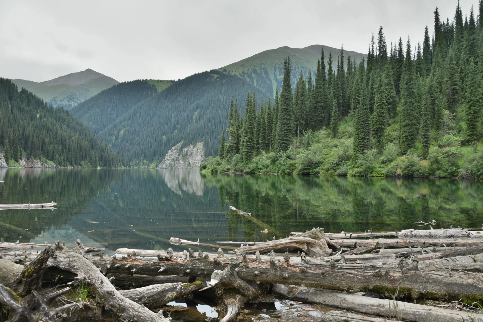
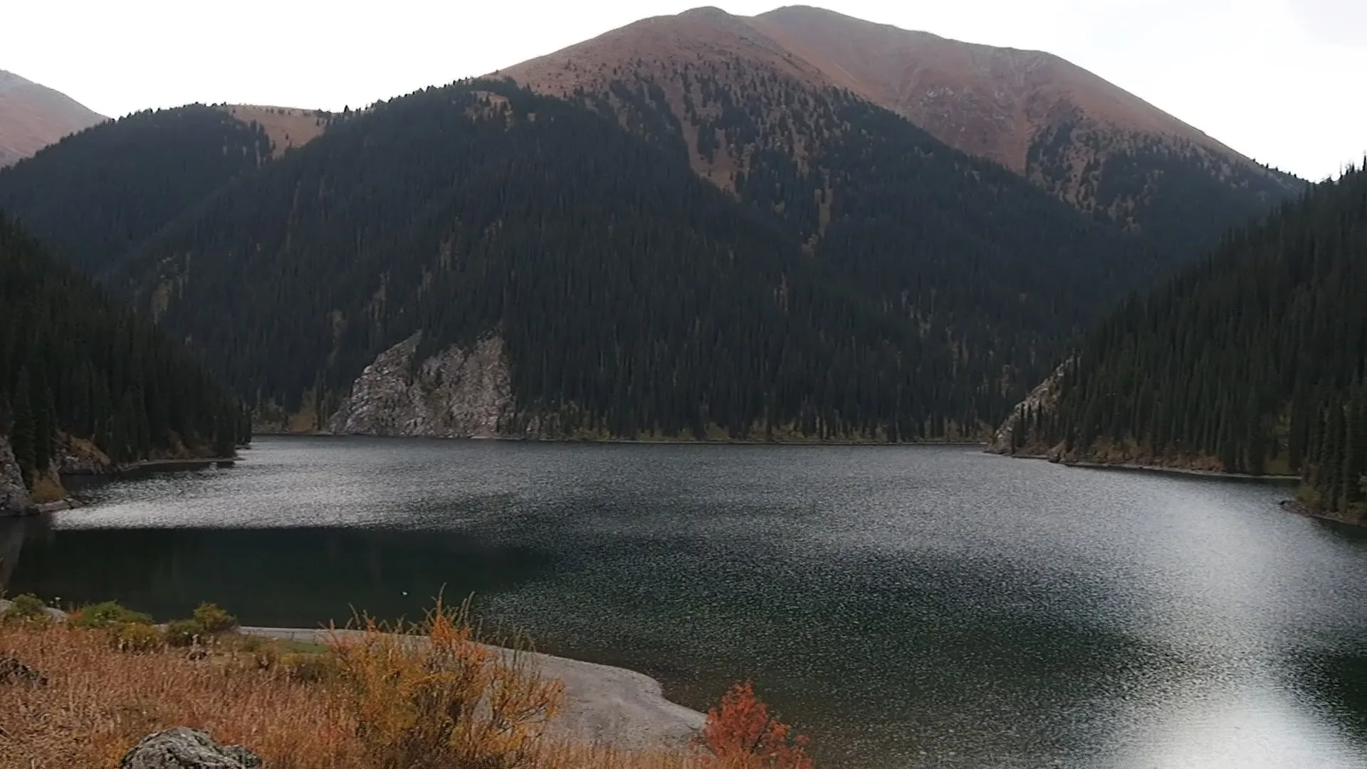
The Kolsai Lakes sit inside Kölsay Lakes National Park in the Kegenskiy District of Almaty Region, tucked into the northern slopes of the Tian Shan at elevations between 1,818 m and 2,850 m. Three lakes occupy the same river gorge, each separated by a few kilometres of spruce forest and steeply climbing trail. The lower lake is the most accessible and has basic guest infrastructure; the middle lake — the largest and most scenic — draws hikers willing to put in a half-day round trip; the upper lake is a genuine backcountry destination, best reached over two days.
The route from Almaty follows the A-351 highway east through Chilik and the Kokpek gorge before turning south through Zhalanash toward the village of Saty. The last 15 km from Saty to the lower lake is a rough gravel track with stream crossings — manageable in a high-clearance vehicle, uncomfortable in a sedan after rain, and reliably served by local UAZ minibuses for visitors without suitable transport. The road to the park gate is paved; carry cash for entry fees and local transport.
The lakes sit within 10 km of the Kyrgyzstan border, and the area carries border-zone (погранзона) status. A formal пропуск (border permit) is required to hike beyond the second lake toward the Sary-Bulak pass and the upper lake. Guards patrol the trail between lakes two and three; without a permit expect to be turned back. Citizens of Kazakhstan and foreign nationals can apply through the eGov.kz portal or at the Almaty border service office; allow several business days and bring your passport to all checkpoints regardless.
Saty village is the practical base: homestays charge around 7,000–10,000 KZT per person including meals. The national park charges a conservation fee (around 738 KZT per person plus 2,584 KZT per standard vehicle as of 2026). There are no ATMs in the area — bring enough cash in Almaty. Mobile signal drops to nothing above the park gate.
Route
Skip map, jump to step listItinerary
Stop 1
Almaty
Depart from Almaty on the A-351 highway heading east. The drive is roughly 330 km and takes around 5–6 hours without stops. Fill the tank in the city — there is no reliable fuel past Chilik, about 90 km out. Stock up on cash, groceries for the trail, and any supplies that might be hard to source in Saty. If you need a border permit for the upper lake, secure it before leaving Almaty; the KNB border service office is in the city.

Stop 2
Saty Village
- From previous:
- 315 km · 310 min drive
- Stay:
- ~8 h
Saty is a small Kazakh farming village at 1,448 m and the practical gateway to the national park. The village has a handful of homestays offering full board for 7,000–10,000 KZT per person; booking ahead in summer is advisable. From Saty the lower lake is 15 km south on a gravel track — drive if you have a high-clearance vehicle, or hire a local UAZ minibus (1,500–2,000 KZT per person). The park gate and fee collection point is at the trailhead.
Stop 3
Lower Kolsai Lake (Kolsai-1)
- From previous:
- 15 km · 30 min drive
- Stay:
- ~4 h
The lower lake sits at 1,818 m, about 1 km long, with a small beach area and a basic restaurant near the entrance. It is the only lake directly accessible by vehicle and the one most day-visitors see. The lake is deep (up to 39 m) and cold year-round. A loop trail around the lower lake takes 3–4 hours at a comfortable pace. Horse rentals are available from local herders at the trailhead for visitors who prefer not to hike upward. For those continuing to the middle lake, the trail climbs roughly 8 km through dense Tian Shan spruce.
Stop 4
Middle Kolsai Lake (Kolsai-2)
- From previous:
- 8 km · 0 min drive
- Stay:
- ~12 h
The middle lake at 2,252 m is considered the most scenic of the three — wider, more open, and backed by higher ridgelines. The 8 km trail from the lower lake gains around 430 m in elevation and takes 3–4 hours one way. Camping is permitted on the grassy meadows at the lake's edge; organized campsites with basic facilities are available. This is the practical turn-around point for a two-day trip without a border permit. The middle lake is also where guards check documents: beyond here, toward the upper lake and the Sary-Bulak pass, a пропуск is mandatory.
What to bring
- Passport (required at checkpoints)
- Border permit (пропуск) if hiking to upper lake
- Cash in KZT (no ATMs near lakes)
- Water filter or 3 L water per person
- Trekking boots with ankle support
- Warm layers (temperatures drop sharply at 2,000+ m)
- Rain jacket
- Sun hat and sunscreen
- Tent and sleeping bag (for overnight to upper lake)
- Food for trail days (no shops beyond Saty)
- Insect repellent (June–August)
- Headlamp
Sources
Researched from English and Russian sources. Inaccuracies are mine.
- https://en.wikipedia.org/wiki/Kolsay_Lakes_National_Park
- https://ru.wikipedia.org/wiki/%D0%9A%D0%BE%D0%BB%D1%8C%D1%81%D0%B0%D0%B9%D1%81%D0%BA%D0%B8%D0%B5_%D0%BE%D0%B7%D1%91%D1%80%D0%B0
- https://wherethesoulswander.com/kolsai-lakes/
- https://brokennavigation.com/travel-guides/central-asia/kazakhstan/detailed-travel-guide-to-visit-kolsai-lakes/
- https://zabugorshiki.com/kolsay-lakes/
- https://central-asia.guide/kazakhstan/destinations-kz/kolsai-lakes/
- https://egov.kz/cms/ru/services/603_knb
Similar trips
Day trip
Big Almaty Lake
A turquoise alpine reservoir at 2,511 m in the Ile-Alatau National Park, roughly 28 km south of Almaty — the city's most accessible high-mountain destination and its primary drinking-water source.
2 days
Charyn–Kolsai–Kaindy Loop
A 2-3 day loop east of Almaty that strings together Charyn Canyon, the three-tiered Kolsai Lakes, and the submerged spruce forest of Kaindy Lake — three of the most distinct landscapes in Kazakhstan in a single circuit.
Day trip
Butakovka Waterfall
A half-day hike into the Butakovka Gorge delivers two tiered waterfalls — 30 m and 20 m — tucked inside Ile-Alatau National Park, barely 20 km from Almaty's city center.